
India gets 24/7 monitoring capability with new satellite
India has launched its first imaging satellite that will operate from geosynchronous orbit, giving the country the ability to obtain frequent, near-real-time images of large areas for disaster monitoring, agricultural, and military purposes.
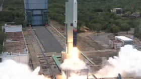
The Earth Observation Satellite-05 (EOS-05) was launched aboard the Indian Space Research Organization’s (ISRO) GSLV-F17 rocket from the Satish Dhawan Space Centre in Sriharikota at 2:55 am on Friday. Around 18 minutes later, it was placed in a transfer orbit.
EOS-05 is intended for “persistent monitoring of [the] Indian region,” ISRO Chairman V. Narayanan told RT India. Unlike India’s existing Earth-imaging satellites in lower orbits, which must pass over the same location again before fresh imagery can be collected, EOS-05 will be able to keep watching the same broad region for much longer periods.
“It is continuously monitoring. You can even take spot photographs,” Narayanan said, adding that its steerable camera can be moved across a designated area to scan selected locations.
Mission Success!
— ISRO (@isro) September 3, 2026
GSLV-F17 has successfully accomplished its mission, placing EOS-05 into the intended orbit.
Sharing a few memorable moments from the lift-off.
For more information:https://t.co/VneB2jgZoY#GSLVF17#EOS05#ISROpic.twitter.com/kv0zB6V5Vi
Lower-orbit satellites can require around a day to return to the same area. By operating from a geosynchronous orbit, EOS-05 reduces that gap and provides more frequent imagery. The capability also has a security dimension.
“You’ve got an eye in the sky, which helps you see exactly what you want to see 24/7, and then gives you that much more reaction time,” retired Indian Army Lieutenant General Arun Sahni told RT India. “I don’t have to wait for a revisit.”
The satellite could strengthen observation along India’s borders with Pakistan and China, he said. India and Pakistan exchanged missile and drone strikes during a brief conflict last year, while Indian and Chinese troops clashed along their disputed Himalayan border in 2020.
Sahni said that constant imagery could help detect changes in terrain, resources, and troop levels along sensitive border areas, giving the military more time to respond.
EOS-05 is expected to help track rapidly developing events such as floods, cyclones, and forest fires, while supporting agriculture and natural resource monitoring. Narayanan also cited weather forecasting, disaster warnings, and flood monitoring as areas that can benefit.
At 2,367 kg, it is the heaviest satellite yet carried by India’s Geosynchronous Satellite Launch Vehicle (GSLV) into a transfer orbit.
The mission was the GSLV’s 19th flight and ISRO’s first successful orbital launch this year. It follows the failure of the PSLV-C62 mission in January after an anomaly in the rocket’s third stage.
An earlier attempt to deploy a geosynchronous Earth-imaging satellite in 2021 also failed because of a problem with the GSLV’s cryogenic upper stage.